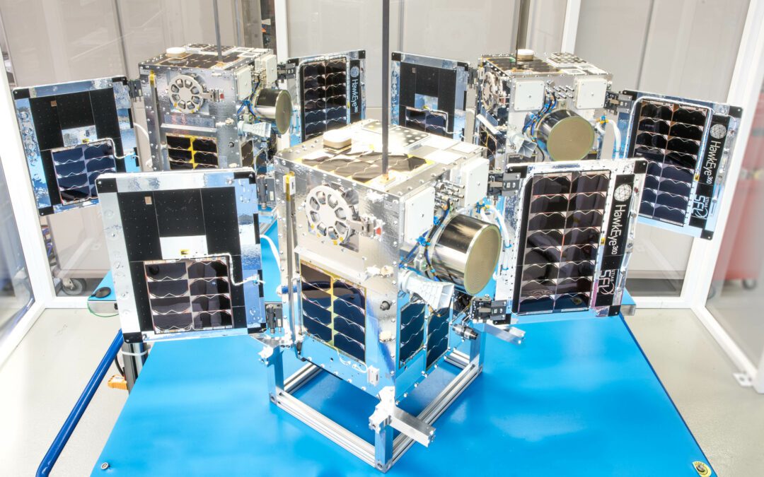
Space Flight Laboratory (SFL) confirmed that six radio frequency geolocation microsatellites developed for HawkEye 360 of Herndon, Va., successfully communicated with ground control.
Space Flight Laboratory (SFL) confirmed that six radio frequency geolocation microsatellites developed for HawkEye 360 of Herndon, Va., successfully communicated with ground control.
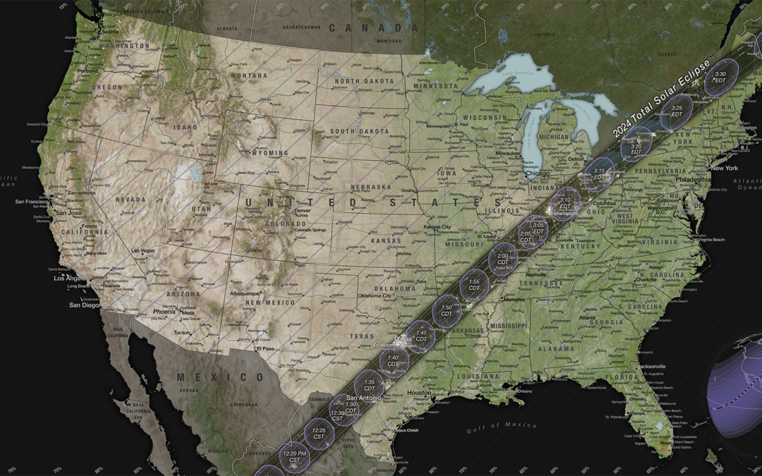
On April 8, 2024, most of North America will have the chance to see the Moon pass in front of the Sun during a solar eclipse.
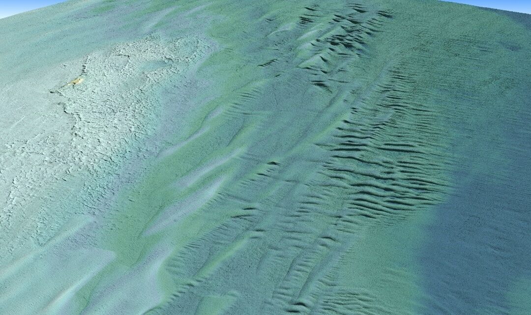
Tetra Tech Inc. used a Teledyne Optech CZMIL SuperNova Topobathymetric lidar system to successfully complete a project for the National Oceanic and Atmospheric Administration (NOAA) to update all its bathymetric maps in the Great Lakes region, which includes refined maps of the marine ecology.
When NASA sends astronauts to the South Pole region of the Moon for the first time with its Artemis campaign, they will capture photos with a handheld camera to help advance scientific research and discovery for the benefit of all.

Manicougan Crater seen from the International Space Station on Feb. 5 2024, by ESA astronaut Andreas Mogensen.
Innovative Collaboration Between Draganfly, Doodle Labs, and UXV Technologies Sets New Standards for UAV Operations San Diego, CA.- Draganfly Inc. (NASDAQ: DPRO) (CSE: DPRO) (FSE: 3U8A) (“Draganfly” or the “Company”), an award-winning, industry-leading drone solutions...
Design of new high-resolution imaging device to meet European Space Agency’s requirements for improved performance in next-generation satellite mission for land monitoring and emergency management Grenoble, France – Lynred, a leading global provider of...
Robust high-accuracy RTK positioning is now easily accessible to drone integrators thanks to Septentrio’s multiple partners Septentrio, a leader in high-precision GNSS* positioning solutions, is closely working with several major drone solutions providers including...
MISSOULA, Mont.- American drone maker Skyfish will unveil Osprey -- at Xponential Booth #4350 -- a new survey-grade, enterprise drone that fits in a backpack. Purpose built for infrastructure inspection and ISR, Osprey supports best-in-class, compact third-party...
NASHVILLE, Tenn. and RESTON, Va.- Arcadus, a technology leader in the digital twin/3D spatial data market serving the Public Sector, and Carahsoft Technology Corp., The Trusted Government IT Solutions Provider®, today announced a strategic partnership. Under the...
Fort Lauderdale, FL- Drone Nerds, a leading consumer and enterprise drone solutions provider, has officially announced a strategic partnership with the newest drone manufacturer to join the industry, Anzu Robotics. Recently emerged in the drone industry, Anzu Robotics...
Rome- e-GEOS, a Telespazio (80%) / Italian Space Agency (20%) company, has been awarded by the European Union Satellite Centre (SatCen) for the renewal of the supply of geospatial products for the Copernicus Security Service component on Support to EU External and...
FAA-Designated Test Site and Leaders to Join Presentations at AUVSI XPONENTIAL GRAND FORKS, North Dakota – Known for results and innovation, the Northern Plains UAS Test Site marks its 10th anniversary this year. The Federal Aviation Administration-designated...
Euroconsult and SpaceTec Partners are merging to create a new company, Novaspace. The two companies that have a combined 60 years of experience in covering the space sector will aim to create a strong combined company in the areas of market...
Paris (France), April 15, 2024 - A revolution in aerial photography is underway. HyLight, the pioneer of aerial inspection using hydrogen airship drones, today announced a fundraising of 3.7 million euros ($4 million) from VCs and business angels including Y...
The first launch under this occurred on Sunday, April 7th., from Kennedy Space Center’s Launch Complex 39A via SpaceX’s Falcon 9 launch vehicle. Using Exolaunch’s proprietary, flight-proven, CarboNIX separation systems, the company successfully...
NAPLES, Fla. - SkyFi, a marketplace for Earth observation data and analytics, is pleased to announce a strategic partnership with True Elements, a pioneering Water Intelligence company providing water data analytics and forecasting. True Elements' state-of-the-art...
LIVERMORE, Calif.- Topcon Positioning Systems has announced strategic agreements with Bentley Systems and Worldsensing to integrate its advanced GNSS (Global Navigation Satellite System) technology into the companies’ innovative software and...
SAN DIEGO - GBT Technologies Inc. (OTC PINK: GTCH) (the “Company”) has recently announced the use in a testing scenario of its innovative Apollo computer vision technology for a Counter-Unmanned Aerial Systems (CUAS) application. VisionWave Technologies, Inc., which...
Expanded Drone Capabilities Will Allow for Low-Risk Asset Monitorization and Inspection WHITE PLAINS—The New York Power Authority (NYPA) today announced that it will be expanding its drone capabilities as part of the asset monitorization and inspection of its electric...
Heerbrugg, Switzerland) Leica Geosystems, part of Hexagon, today announced the launch of Leica iCON gps 120 — a smart antenna designed to further empower construction professionals with scalable and flexible machine control solutions. The new Leica iCON 120...
SANTA FE, New Mexico – Descartes Labs Government (DLG) is announcing the launch of Retina (Rapid Exploitation Through Interactive Analysis) at GEOINT 2024. Retina is an innovative solution that integrates Open Source Intelligence (OSINT) and Geospatial...
The most significant release of UgCS, the best and most powerful flight planning tool for drone pilots, has landed! SPH Engineering is proud to announce the release of UgCS 5.0, marking a major milestone in drone flight planning software evolution. The...
New API has multiplier effect by opening L-band SAR analytics to Earth Observation and GIS-based ecosystem San Diego – Today, ASTERRA launched their new application programming interface (API), which unlocks the vast potential of SAR analytics to possible...
The most significant release of UgCS, the best and most powerful flight planning tool for drone pilots, has landed! SPH Engineering is proud to announce the release of UgCS 5.0, marking a major milestone in drone flight planning software evolution. The...
SAN DIEGO - ModalAI, Inc. today announced Starling 2 and Starling 2 Max, the latest iterations of their popular VOXL 2 development drone, now refreshed and compliant with NDAA regulations. These new designs feature upgraded image sensor suites for reliable indoor...
Reveal, the world’s leading underground utility data management company, is launching a new Data as a Service product called Underdots, which massively speeds up the analysis of ground penetrating radar data for utility locators. Underdots creates an intuitive,...
TURIN, Italy - Tyvak International SRL (“Tyvak International”), a Torino, Italy-based subsidiary of Terran Orbital Corporation (NYSE: LLAP) and a leading European provider of nano and microsatellites, announced the successful launch of Fleet Space Technologies’...
Production-ready 1.0 version expected to unleash untold mapping services and product innovations SAN FRANCISCO - The Overture Maps Foundation (Overture), a collaborative effort to enable current and next-generation interoperable open map services and...
Tackling security and Public Safety Challenges across the United States SAN DIEGO - ideaForge Technology Inc. (a subsidiary of ideaForge Technology Limited), a leading global drone technology and manufacturing company, announces the launch of new innovative...
COLUMBIA, Md.-RouteSmart Technologies, a leader in route planning and optimization solutions, has released a new suite of tools designed to enhance waste management services for clients who collect garbage and recycling in alleyways. This innovative feature in...
Faster Overall Workflow AARSCHOT, Belgium – Virtual Surveyor has enhanced its popular smart drone surveying software with new planimetric survey capabilities. In addition to multiple performance modifications, Virtual Surveyor version 9.5 now enables users to...
LAS VEGAS - Quanergy, a leading provider of 3D LiDAR technology for physical security and business intelligence applications, is showcasing two new additions to its portfolio of 3D LiDAR solutions here at ISC West 2024 in booth 32057. The new Q-Track HD and Q-Track...
Waterloo, CANADA, April 9, 2024 – Teledyne will feature their latest products and solutions at AUVSI XPONENTIAL 2024 taking place April 22- 25, 2024, in San Diego, California. Visitors to the Teledyne booth #3325 can expect innovative solutions for unmanned systems...
TORONTO, Ontario, Canada, 8 April 2024 – Space Flight Laboratory (SFL) confirmed that six radio frequency geolocation microsatellites developed for HawkEye 360 of Herndon, Va., have successfully communicated with ground control. The HawkEye 360 Cluster 8 and 9...
The Gloria Barron Prize for Young Heroes is a national award that celebrates inspiring, public-spirited young people from across the U.S. and Canada. Established in 2001 by author T. A. Barron, the Barron Prize annually honors 25 outstanding young leaders ages 8 to 18...
London, 23 April 2024 – The Association for Geographic Information (AGI), the membership group for organisations and individuals working in the geospatial sector, will present its Awards for Excellence at the UK’s largest geospatial event GEO Business. Working with...
GEO Business, the UK's largest geospatial event, returns to ExCeL London on 5-6 June 2024. GEO Business is a platform for you to connect with the geospatial community and unlock the potential of geospatial innovation. This free-to-attend expo acts as...
Draganfly to Speak at Law-Tech Connect™ Panel During AUVSI XPONENTIAL 2024 San Diego, CA.- Draganfly Inc. (NASDAQ: DPRO) (CSE: DPRO) (FSE: 3U8A) (“Draganfly” or the “Company”), an award-winning, industry-leading drone solutions and systems developer is pleased to...
Support continues to grow as Commercial UAV Expo celebrates its tenth edition of the tradeshow and conference. PORTLAND, MAINE – Commercial UAV Expo, the world’s leading commercial drone trade show and conference, has announced a massive list of more...
Presentations to shine light on Teledyne’s wide technology developments Trenton, New Jersey, USA – Teledyne will showcase their array of products and solutions at SPIE’s Defense and Commercial Sensing exhibition taking place April 23-25 at the Gaylord Convention...
Marbell will lead Woolpert’s geospatial business development strategy and expansion throughout Africa, Latin America, and the Caribbean. DENVER — Woolpert has hired Geospatial Program Director William Marbell to support its strategic business development and expand...
Waterloo, CANADA, April 9, 2024 – Teledyne will feature their latest products and solutions at AUVSI XPONENTIAL 2024 taking place April 22- 25, 2024, in San Diego, California. Visitors to the Teledyne booth #3325 can expect innovative solutions for unmanned systems...
Tomaž Petek, General Manager, Surveying and Mapping Authority of the Republic of Slovenia, was elected President of EuroGeographics at the not-for-profit Association’s 2024 General Assembly. He succeeds Colin Bray, Tailte Éireann, who has held the position since...
Melanie Stricklan to Spearhead Space Talent Initiative Colorado Springs, Colo.- Space Foundation and Space Workforce 2030 are proud to announce the appointment of Melanie Stricklan as the inaugural Executive Director of Space Workforce 2030, a first-of-its-kind...
HERNDON, Va.- HawkEye 360 Inc., the world's leading defense technology company for space-based radio frequency (RF) data and analytics, announced its new members of the Advisory Board, forming the Class of 2024 today. Retired Generals, Gen. David D. Thompson, and Lt....
Commercial UAS industry leaders will provide guidance for the landmark 10th edition by serving on Commercial UAV Expo Advisory Board Portland, Maine – Organizers of Commercial UAV Expo, the world’s leading commercial drone trade show and conference, have...
BOSTON (MA) – This July, the 13th annual International Space Station Research and Development Conference (ISSRDC) returns to Boston, where leaders from the commercial sector, U.S. government agencies, and academic communities will assemble to highlight...
MADRID - Ommatidia LiDAR, a leading innovator in Light Detection and Ranging (LiDAR) technology, is pleased to announce the addition of Frank Petznick as an Independent Director. With a distinguished career in technology and innovation in the automotive industry,...
LOS ANGELES - ESP received the Analytics Award at the 2024 Esri Partner Conference (EPC) held March 10–11, 2024, in Palm Springs, CA. This award was presented to ESP for innovation with analytics or AI for solutions, content, or services offerings. ESP, a software...
